Historic Tornado Threat Builds Across Great Plains to Great Lakes
Meteorologists are urgently monitoring a developing severe weather pattern that could trigger a major tornado outbreak stretching from the Great Plains to the Great Lakes region during the final ten days of May 2026. Leading forecasting models, including the Euro Ensemble Model, signal a significant intensification of tornado and severe storm activity reminiscent of the notorious 2004 tornado season.
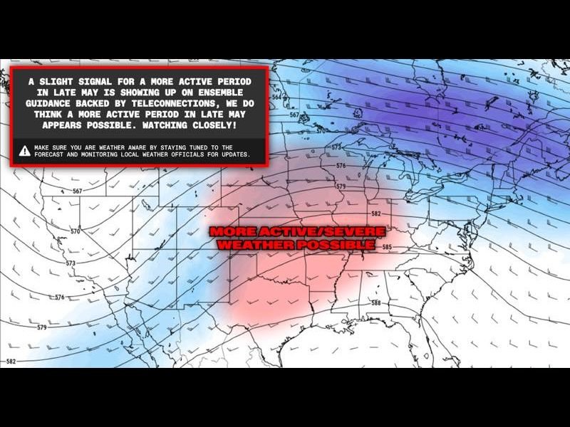
The European Ensemble Model, widely regarded for its reliable long-range forecasts, issued a strong indication on its May 7, 2026 run for a late-May surge in severe weather. This forecast is reinforced by teleconnection data, which shows the atmosphere becoming increasingly primed for widespread severe storms across central U.S. areas as the month concludes. While forecasters caution about inherent uncertainties with long-range models, the consistency across multiple runs has raised alarms among experts and emergency managers.
Classic Atmospheric Setup Fuels Tornado Risk
The severe weather potential is driven by a textbook trough-ridge pattern across the United States, a configuration notorious for creating the ideal ingredients needed for violent tornado outbreaks. This setup enhances wind shear, moisture influx, and atmospheric instability across the Great Plains and points eastward toward the Great Lakes corridor.
Wind analyses at the 500mb atmospheric level reveal this developing trough-ridge pattern centered over the central and southern plains states, marking a zone with elevated severe weather threat potential. This kind of pattern often leads to long-track, multiple tornado events impacting a broad stretch of states.
2004 Tornado Season Comparison Rings Alarm Bells
The forecast’s most unsettling aspect is the direct comparison to the 2004 tornado season, which produced an unprecedented series of powerful tornadoes across multiple states over an extended timeframe. If current signals verify, late May into June 2026 may see a similarly violent and sustained tornado outbreak erupt.
This forecast raises the threat level sharply for communities not only in the Great Plains—from Montana’s neighbors to the south and east—but also across the Mississippi Valley and the Great Lakes region, potentially impacting millions of people with life-threatening storms.
Communities Urged to Prepare Immediately
With the active severe weather window set to open within days, residents and local authorities across high-risk regions are urged to review emergency plans, ensure weather alert devices are working, and stay closely tuned to updates from trusted sources.
“The latest Euro Ensemble forecast is a clear call to action — this could be a historic period for severe weather,” said a senior meteorologist monitoring the outbreak potential. “Preparedness now could save lives once the storms begin.”
Montana’s connection to this threat lies primarily in the potential for severe weather spreading eastward from the Plains and south-central U.S. toward northern states and upper Midwest regions. While Montana itself is not at the center of the predicted outbreak zone, heightened tornado season activity could signal a turbulent summer ahead for the broader region.
What to Watch Next
Forecasters will continue to track the evolving atmospheric conditions closely through late May, with critical updates expected as model data refines. The potential for multiple days of severe weather spanning tornado-producing storms is escalating, demanding vigilance among residents and emergency services alike.
For constant severe weather updates and expert storm tracking across the United States, readers are encouraged to follow SaludaStandard-Sentinel.com as the situation develops.
Stay informed, stay ready, and take severe weather threats seriously as this historic tornado season threat unfolds.