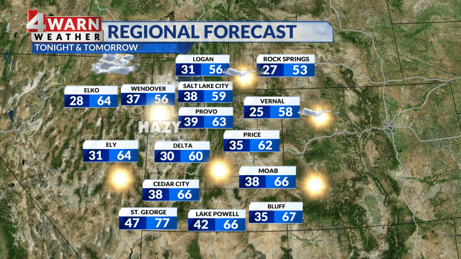
URGENT UPDATE: Hazy sunshine and warming temperatures are sweeping across Utah today, bringing daytime highs closer to seasonal averages. After a chilly start to the week, a ridge of high pressure is taking control, with temperatures climbing into the upper 60s along the Wasatch Front and reaching the low 70s in St. George.
Expect dry skies statewide, but beware of the haze lingering in the valleys. This is the beginning of Inversion Season, where a layer of warm air traps cold air—and pollutants—below. The Department of Air Quality has already issued a forecast indicating “moderate air” quality for Davis, Salt Lake, and Utah counties, with elevated particulate matter expected today.
As the haze builds, residents are reminded that these conditions can lead to a decline in air quality. If you’re new to Utah, it’s important to know that we need air mixing or a storm to clear these inversion conditions. The geography of our mountains limits this mixing, especially with a high-pressure system in place.
Looking ahead, Halloween promises clear skies and dry conditions, making it a great night for trick-or-treating. Temperatures are expected to reach the low 60s along the Wasatch Front and the upper 70s in Washington County. As night falls, temperatures will drop from the 70s to the 60s in southern Utah, and from the 50s to the 40s in northern Utah.
As we transition into November, similar weather patterns are anticipated. Expect above-average warmth and dry skies to continue into the first week of the month. Additionally, don’t forget that this weekend marks the end of Daylight Saving Time. Set your clocks back one hour before bed on November 4 at 2 AM. While we gain an hour of sleep, prepare for shorter days and earlier sunsets.
Stay tuned for the latest updates from our 4Warn Weather forecast, both on-air and online. We are committed to keeping Utah informed as conditions develop.