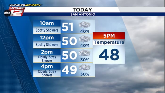
UPDATE: A significant cold front is moving through the area this morning, bringing a drastic drop in temperatures and the potential for light showers. Residents should brace for a transition from the mid-50s to the upper-40s by this evening, making it essential to prepare for chillier conditions.
As the cold front sweeps in, fog and drizzle are expected to affect visibility and road conditions throughout the morning. According to the latest data from the KSAT Weather Authority, light showers will intermittently impact the region, particularly during the morning commute, adding to the urgency for drivers to remain cautious.
Friday morning will see another wave of light rain, potentially disrupting travel plans as temperatures hover around 50°F by the afternoon. Despite a slight warming trend, conditions will remain damp and chilly. The rain is expected to clear out by Friday evening, bringing relief to those eager for a respite from the wet weather.
Looking ahead, a beautiful weekend is on the horizon. Sunshine will return on March 16 and March 17, with temperatures soaring to near 70°F on Saturday. Although a weak front may bring some breeziness on Sunday, no significant rain is in the forecast, making it an ideal time for outdoor plans.
For real-time updates, residents can access the KSAT Weather Authority App, providing up-to-date forecasts and live weather coverage. Stay safe and prepared as this cold front passes through, and enjoy the pleasant weather expected this weekend!